|
|
Project concepts
|
|
|
The scenarios
|
This project compares the probability of various weather events between two scenarios:
- "Real world": The world we have experienced, with increasing greenhouse gas concentrations and month-to-month and year-to-year variations in sea surface temperatures.
- "Non-GHG world": An estimate of what the world might have been like had human activities never interfered with the climate. In the simulations this involves reducing the greenhouse gas concentrations to pre-industrial levels and coolling the ocean surface according to a spatially-varying estimate of how much greenhouse gas emissions have warmed it.
We then run number of simulations under both scenarios and compare the chance of exceeding a certain threshold within each of these collections of simulations.
|
|
|
|
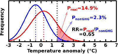
(Note the "RR" is the Risk Ratio, the ratio of the chances of an event in the two scenarios, and is the measure underlying our posted conclusions.)
|
|
|
|
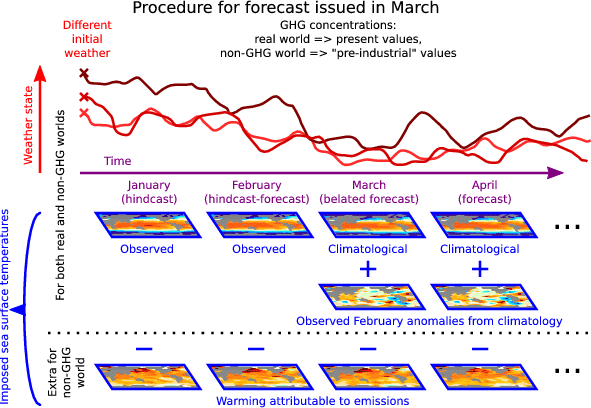
The forecast/hindcast mode
|
Results are posted on the web site for two types of estimates of how much our emissions have affected extreme weather events:
- "Forecast": These estimates are generated one month in advance. For the "real world" scenario they use a simple forecast of the sea surface temperatures, while for the "non-GHG world" scenario they use the same ocean temperature forecast minus an estimate of how much our emissions ahave warmed the planet.
- "Hindcast": Two months after the event we can use observations of the actual sea surface temperatures experienced during that month. We then perform the simulations again using these ocean temperatures instead of the forecast ones.
Under the assumptions underlying the experimental setup of this project, it should not matter whether we are using forecast or observed sea surface temperatures. In fact, we have found in some analyses that it can make a difference. Thus the spread of results between the forecast and hindcast estimates can be used as an indication of uncertainty in our understanding of how our emissions have changed the chance of an event.
|
The experimental design is summarised with this figure:
|
|
|
|
|
|
The climate models
|
| HadAM3-N48 |
A dynamical model of the atmosphere produced by the U.K. Met Office Hadley Centre. It solves equations describing the evolution of the atmospheric state on a polar grid with a spatial resolution of 3.75 degrees in longitude and 2.5 degrees latitude with 19 vertical levels (More information here)
|
| HadAM3P-N96 |
A dynamical model of the atmosphere produced by the U.K. Met Office Hadley Centre. It is a modified version of HadAM3 that runs at a higher spatial resolution (1.875x1.25 degrees) and uses different methods of estimating the effects of small-scale processes.
|
|
|
|
|
The regions
|
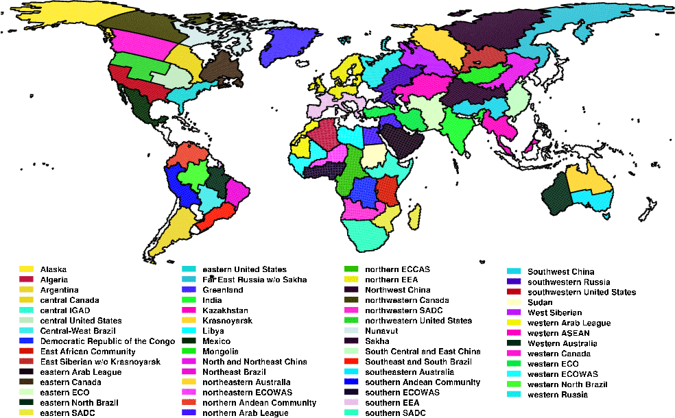
Currently we estimate the contribution of greenhouse gas emissions to the change in the chance of an unusually (1-in-10-year) hot, cold, wet, and dry month for each of the regions in the map below. These regions are based on political-economic entities of approximately 2 million km2 in size. Some countries (in white) are unfortunately not included because their marine nature means they are not properly simulated within our modelling setup.
|
|
|
|
|
Last update:
12 October 2013
|
|
Contact: Dáithí Stone (dstone@lbl.gov)
|
|
|
© Copyright 2009-2013 Contributors to the Weather Risk Attribution Forecast
|
|
|